
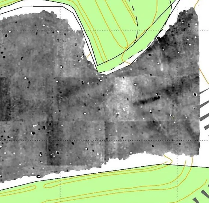
KB GPR Surveys had the opportunity to survey Buckland Rings, an Iron Age hillfort in the New Forest, Hampshire. We worked in partnership with the New Forest National Park Authority and Bournemouth University. The survey produced images of major features from the Iron Age occupation of the site, which lasted several centuries.
Iron Age hillforts
The Iron Age covers the centuries before, and up to, the Roman invasion of Britain in AD 43. During this period many settlements were built with what are usually seen as defensive banks and ditches around an area of occupation.
Hillforts vary widely in size and shape. Their builders always used the natural landform to their advantage, combining it with man-made banks and ditches to mark a clear boundary between inside and outside.
Archaeologists, geophysicists and other specialists continue to study hillforts. There are no written records from the period, and much about these sites is still not understood. Many theories have been put forward about how they were used, but their exact purpose remains uncertain.
A protected site
Buckland Rings is a Scheduled Monument. That means it is legally protected and cannot be disturbed without Scheduled Monument Consent (SMC). Non-invasive survey methods such as GPR are especially valuable on sites like this, because they add to what is known without disturbing the archaeology.
How the survey was done
The survey ran on 3 and 4 September 2018. We used a three-channel GPR array towed behind an all-terrain vehicle, with GNSS positioning recorded alongside the radar data. On-site tests showed the higher frequency could not reach the depth needed, so the survey used the 400 MHz channels only. That set-up covered 1.9 hectares in two days, and the signal reached about 2.5 m below the surface.
GPR sends radio pulses into the ground and records reflections where the soil or buried material changes. Ditches, pits, post holes, floors and compacted surfaces each produce a response. Processed into plan views at different depths, the data shows the layout of buried features across the site.
What the GPR found
The survey possibly identified:
- roundhouses
- internal divisions within the enclosure
- trackways
- an entrance way
- pits
These are interpretations from the data. Excavation would be needed to confirm them.
GPR, magnetometry and EM compared
Buckland Rings had already been studied with magnetometry and EM (electromagnetic conductivity) survey. Our GPR data was added to those earlier results, which gave a rare chance to compare the three methods over the same ground.
| Method | What it measures | Strengths | Weaknesses |
|---|---|---|---|
| Magnetometry | Small changes in the earth's magnetic field, often from burning (hearths, kilns) | Fast; covers large areas; good at finding signs of human activity | Poor at layers and stratigraphy; misses walls unless they are magnetic; some geology, such as limestone, masks the response |
| EM (conductivity) | How well the ground conducts electricity | Fast; works in wet and dry ground; finds large features, buried metal and landfill | Little fine detail; metal causes interference; hard to separate depths |
| GPR | Reflections where buried materials change | Fine detail and depth; finds walls, pits, floors, voids and layers; choice of frequency for depth or resolution | Loses depth in wet clay; metal blocks the signal; needs contact with the surface |
GPR is often treated as a follow-up method, used after magnetometry or EM. At Buckland Rings it gave the most detailed results of the three. Towed with GPS positioning, it was also quick, and it showed features that 25 years of earlier geophysics had not found.
The combined work helped the New Forest National Park Authority prepare a paper and an oral presentation comparing surveys from around 25 years earlier with those done today.
The limits
Every geophysical method has strengths and weaknesses, and ground conditions matter. GPR can lose depth in wet clay soils, and features that are similar to the surrounding soil may give little contrast. On many sites the best results come from using more than one method and reading them together.
References
- Clay, R. B., 2005. Conductivity (EM) Survey: A Survival Manual.
- Fassbinder, J., 2017. Magnetometry for Archaeology. In: Encyclopedia of Geoarchaeology. Springer, pp. 499–514.
- Green, F., 2018. Buckland Rings Project Report. Lymington: New Forest National Park Authority.
- Howard, B., 2018. Buckland Rings Archaeological Report. Southampton: KB GPR Surveys Ltd.
- Schmidt, A. R. et al., 2015. EAC Guidelines for the Use of Geophysics in Archaeology. Europae Archaeologia Consilium.
Talk to us
If you are researching a hillfort, earthwork or other historic site, see our archaeological GPR survey page or contact us.